
Practice session
Information signs
Loading…
Every question on this page
The whole pool, with the answer and the explanation for each one. Practise first, then read through anything you were unsure of.
Show all 16 questions with answers
1 of 16 · Information signs
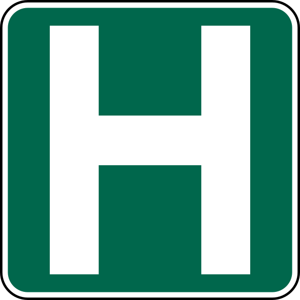
What does this information sign show you?
- A.A helicopter may land on the road ahead
- B.An off-road facility such as a hospitalAnswer
- C.A highway rest area is ahead
- D.A hotel is located at the next exit
Explanation: This kind of information sign shows off-road facilities such as hospitals, airports, universities or carpool lots.
2 of 16 · Information signs
What kind of information do green signs like this one give you?
- A.Directions, exits and distances to destinationsAnswer
- B.Warnings about hazards on the road ahead
- C.Rules you must obey, such as speed limits
- D.Places of interest for tourists
Explanation: Green signs guide you: this one shows which lane leads off the freeway, while others show distances in kilometres to towns ahead.
3 of 16 · Information signs
You catch up to a vehicle displaying this orange triangle. What does it tell you?
- A.The vehicle travels at 40 km/h or lessAnswer
- B.The vehicle is carrying dangerous goods
- C.The vehicle has broken down
- D.The vehicle is escorting a wide load
Explanation: The orange triangle with a red border alerts other drivers that the vehicle ahead will be travelling at 40 km/h or less. Watch for these slow moving vehicles and reduce your speed as necessary.
4 of 16 · Information signs
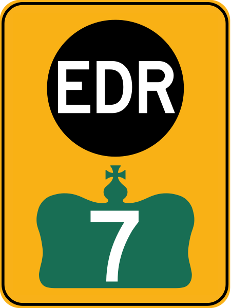
When do you follow the route marked with these emergency detour route signs?
- A.During rush hour, to avoid congestion
- B.When a provincial highway is closed unexpectedly and all traffic is detoured off itAnswer
- C.When you need fuel, food or a place to stay
- D.When you are towing a trailer
Explanation: EDR signs are used during the unscheduled closure of a provincial highway when the OPP detour all traffic off the highway. The markers are located along alternative routes and lead you around the closure and back onto the highway.
5 of 16 · Information signs
What does the number on a freeway interchange or exit tell you?
- A.How many exits there are before it
- B.The distance in kilometres from the beginning of the freewayAnswer
- C.The speed limit on the ramp
- D.The number of lanes the exit has
Explanation: Exit numbers are distances, not a count. Interchange 204 on Highway 401 sits 204 kilometres from Windsor, where that freeway begins — so the gap between two exit numbers is the distance in kilometres between them.
6 of 16 · Information signs
On an advance freeway sign, how are the lanes that lead off the freeway marked?
- A.Their arrows sit in a yellow box with the word “exit” under themAnswer
- B.Their arrows are shown in red
- C.They are left off the sign entirely
- D.They are marked with a number instead of an arrow
Explanation: The advance sign shows an arrow for each lane, and the ones that leave the freeway are boxed in yellow with “exit” written under them. Reading it early is the point: in an urban interchange more than one lane may peel off, and the sign is how you know which one you are in.
7 of 16 · Information signs
What does this green sign tell you?
- A.The distances in kilometres to towns and cities aheadAnswer
- B.The speed limit for the next stretch of road
- C.Which services are available at the next exit
- D.The route to the nearest hospital
Explanation: Green with white lettering is the colour for distances and destinations: this one gives the kilometres to the towns and cities on the road ahead. Facilities, services and attractions are signed in other colours.
8 of 16 · Information signs
You pass an information sign that is not green. What is it likely to be pointing you to?
- A.Facilities, services and attractionsAnswer
- B.A change in the speed limit
- C.A hazard on the road ahead
- D.A rule you must obey
Explanation: Green carries distances and destinations; the other colours in the information family guide you to facilities, services and attractions — fuel, food, lodging, a tourist site. None of them is an order, which is what separates information signs from regulatory ones.
9 of 16 · Information signs
You are approaching a roundabout and see a sign listing its exits. What is it for?
- A.It shows the upcoming exits and where each one takes youAnswer
- B.It tells you which exit has the right-of-way
- C.It sets the speed limit inside the roundabout
- D.It marks where you must stop before entering
Explanation: It is an information sign, not an instruction: it shows the upcoming roundabout exits and where they will take you. Read it before you enter — once you are going round, choosing a lane by reading signs is far harder.
10 of 16 · Information signs
A green sign names a destination with the word “VIA” above a route number. What is VIA telling you?
- A.The roads you must follow to reach that destinationAnswer
- B.The distance to that destination
- C.An alternative route to use only when the highway is closed
- D.The name of the municipality maintaining the road
Explanation: VIA names the roads that must be followed to reach a destination. It answers “by which way”, not “how far” — the distance is the number beside the place name on a destination sign.
11 of 16 · Information signs
An overhead sign on the freeway changes its message while you watch. What kind of sign is it?
- A.A toll rate display
- B.One that reports current delays and lane closures aheadAnswer
- C.An advertising board, which you may ignore
- D.A speed limit sign that changes with the weather
Explanation: These signs change according to traffic conditions to give drivers current information on delays and lane closures ahead. What they show is as fresh as the traffic itself, so it is worth reading even when the road in front of you is still moving.
12 of 16 · Information signs
The truck ahead of you carries a placard on the back marking it as a long commercial vehicle (LCV). What should you expect?
- A.A truck that is about to make a wide right turn
- B.An oversize load with an escort vehicle behind it
- C.A double trailer up to 40 metres long, travelling at a limited speedAnswer
- D.A vehicle carrying dangerous goods
Explanation: An LCV is a double trailer that can be up to 40 metres in length. Recognising one from behind matters because of what passing it involves: far more road than a single trailer needs, against a vehicle that is also limited in speed. Plan the pass before you start it, or stay back.
13 of 16 · Information signs
You are driving in a designated bilingual area and the signs carry both English and French. What should you do?
- A.Read the English, which is the legally binding version
- B.Read both, since the two messages differ
- C.Treat a French-only sign as advisory rather than binding
- D.Read the message in whichever language you understand bestAnswer
Explanation: Read the message in the language you understand best. The two say the same thing, and they may share one sign or come one after the other — an English sign immediately followed by a French one.
14 of 16 · Information signs
Some information signs carry a row of numbers along the bottom edge. What is that numbering for?
- A.It helps emergency vehicles and drivers work out an appropriate routeAnswer
- B.It gives the year the sign was installed
- C.It is the phone number of the road authority
- D.It shows the posted speed limit in that section
Explanation: Emergency response numbering runs along the bottom of some information signs so that emergency vehicles — and the driver phoning them — can pin down where they are and work out a route to it. It is not part of the message the sign is otherwise giving you.
15 of 16 · Information signs
Interchange 204 on Highway 401 is 204 kilometres from Windsor, where the freeway begins. How do you work out the distance from one interchange to another?
- A.Read it off the distance sign; the numbers mean nothing by themselves
- B.Subtract one interchange number from the otherAnswer
- C.Count the interchanges in between and multiply by two
- D.You cannot — the numbers are assigned in order, not by distance
Explanation: Freeway interchange numbers are the distance in kilometres from the beginning of that freeway, so the gap between two of them is the distance between them: subtract one number from the other. It is the quickest way to know how far your exit still is, with nothing but the signs you are already passing.
16 of 16 · Information signs
A sign carries a wheelchair symbol. What is it telling you?
- A.A hospital is ahead
- B.Watch for pedestrians with disabilities crossing here
- C.The facilities it points to are accessible by wheelchairAnswer
- D.Only drivers with a disability permit may continue
Explanation: The wheelchair symbol on an information sign says the facilities it directs you to are accessible by wheelchair. Like the rest of the information family it describes what is there; it orders nothing, which is what keeps it out of the regulatory group.